Apple Maps launches Detailed City Experience in Austin, Texas, completely rewriting how millions navigate the Lone Star State capital right before the high-octane Formula 1 Grand Prix.
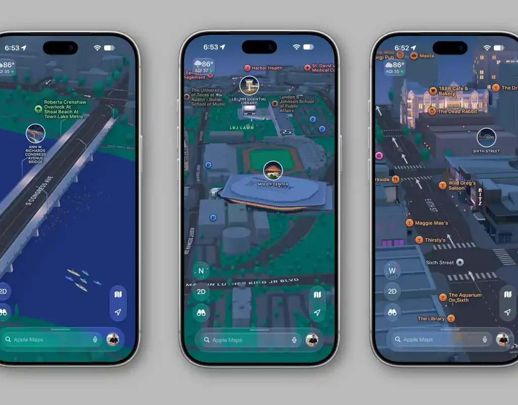
- Massive Visual Overhaul: Unlocks custom-modeled 3D landmarks across Austin, from the Texas Capitol to a bespoke digital twin of the Circuit of the Americas.
- Driver & Pedestrian Precision: Delivers dedicated turn lanes, crosswalk geometries, elevation contours, and road markings directly to iPhone screens and CarPlay.
- Zero Additional Cost: The update is rolling out globally over-the-air across iOS, iPadOS, and macOS platforms without requiring paid map packages.
Can this bespoke digital transformation finally dethrone Google Maps from its long-held navigation throne?
In plain terms, Apple’s Detailed City Experience replaces flat satellite tiles with hand-crafted 3D spatial models and accurate road physics.
Consequently, drivers get lane-level guidance showing exact turning pockets and median strips rather than confusing, ambiguous directional arrows.
The rollout went live at 4:03 PM PT (7:03 PM ET / 11:03 PM GMT) on October 14, 2026.
Industry observers confirmed that Austin marks the latest major tech hub to receive the full custom treatment, expanding coverage across more than 35 cities worldwide.
Every single neighborhood now reflects authentic elevation changes, indigenous tree canopies, and architectural textures that mimic the real world.
Furthermore, prominent cultural monuments have received painstaking artistic attention.
Users zooming past downtown can spot the ornate pink granite facade of the Texas Capitol.
Similarly, soccer fans will find an authentic 3D structure representing Q2 Stadium in North Austin.
Art enthusiasts will immediately recognize the distinct exterior contours of the Blanton Museum of Art.
Historic venues also shine, including the iconic marquee of the Paramount Theatre.
Even urban wildlife made the cut, with animated bat silhouettes rendering over the Ann W. Richards Congress Avenue Bridge.
In addition, tech enthusiasts can spot hand-crafted designs for commercial hubs like Apple Domain Northside and local institutions like Black’s Barbecue.
Yet the crown jewel of this regional update centers squarely on motorsports.
Ahead of the international crowds descending for race weekend, Apple mapped the entire Circuit of the Americas track facility.
Racegoers get custom 3D track elevation, grandstand markers, entry gate locations, rideshare drop zones, and pedestrian pathways.
Spectators navigating the venue on foot will experience clear pathfinding across miles of expansive festival grounds.
When the sun sets, the software seamlessly triggers a nighttime mode with a moonlit glow reflecting off virtual glass and water.
| Feature / Metric | Detailed City Experience Spec | Standard Digital Mapping Baseline |
|---|---|---|
| City Platform | Austin, Texas (Live Worldwide) | Flat 2D Vector Basemaps |
| Bespoke 3D Assets | Texas Capitol, COTA, Q2 Stadium, Paramount | Generic Polygonal Extrusions |
| F1 Circuit Support | Turn-by-turn walking gates, grandstands, transit | Outer venue boundary outline only |
| Turn Navigation | Median strips, dynamic lane markings, crosswalks | Simplified directional path overlay |
| Access Requirements | iOS 15+, iPadOS 15+, macOS 12+ | Web & native mobile clients |
| Global Access Price | $0.00 / £0.00 / €0.00 (Free system update) | Free with in-app advertising |
Behind the scenes, automotive sources note that Apple’s engineering team logged hundreds of drive hours with lidar-equipped vehicles.
These camera arrays capture physical elevation changes down to the centimeter, rendering true-to-scale roadway inclines.
Therefore, drivers tackling complex multi-lane splits along Interstate 35 gain clear visual indicators well before approaching tricky exits.
CarPlay users will especially appreciate the tactical clarity during heavy evening traffic jams.
Meanwhile, country music fans get an exclusive curated guide highlighting singer Dylan Gossett’s favorite Austin venues.
The Bigger Picture:
By embedding bespoke event venues into its mapping core, Apple transforms standard navigation into an immersive entertainment ecosystem. Google still controls roughly 70% of global navigation volume, yet Apple’s design-first strategy targets high-value metropolitan corridors where user loyalty translates directly into hardware upgrades.
My Take:
Navigating downtown Austin has historically tested anyone’s patience, particularly when sudden lane splits force blind merges.
This update turns chaotic intersections into intuitive visual models that genuinely ease driving stress.
Google Maps may still retain superior raw crowdsourced business hours, but Apple Maps just proved that meticulous craftsmanship still matters.
- K.K., Founder of TechKomo